Category: Hiking

  • These Are a Few of my Favorite Things

    These Are a Few of my Favorite Things

    ok — one of my favorite things.

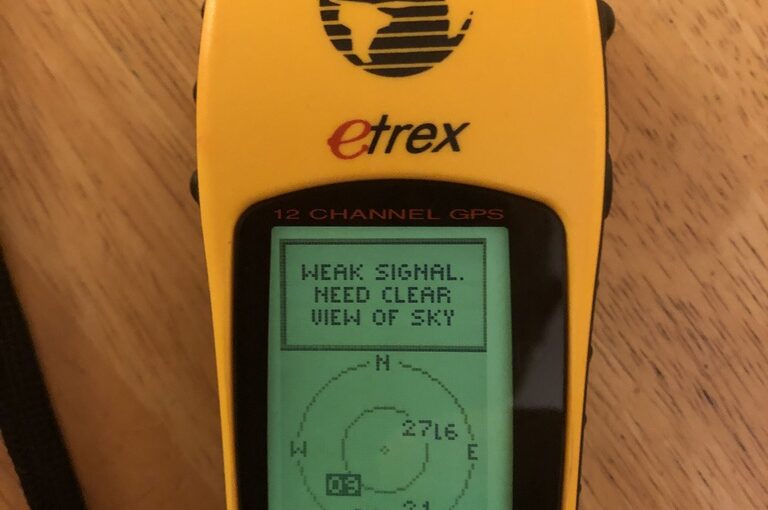
    It’s my old Garmin eTrex! A friend’s son is going to be working at Garmin for the summer, and I was reminiscing about my long history with their products. This was my first — the original eTrex. I can still remember going to a MacWorld exhibition back in 1989 or 1990 and seeing a Sony GPS unit (yes, Sony!). It must have been a Pyxis model, though my recollection was that the antenna unit was spherical rather than just round. Could be faulty memory, or might have been a prototype unit. More likely the former. Anyway, it was of course super expensive, and there was no way I would be able to afford such a thing, but the concept of a (semi) portable device that could tell you (fairly) precisely where you were anywhere on earth seemed pretty magical.

    In any case, GPS technology continued to evolve, and a newish company, Garmin, was producing some interesting devices. A lot of the early devices were aimed at the boating market, where LORAN had been the previous popular means of electronic navigation. There were some handheld units, but the eTrex was (I would say) the first reasonably priced, handheld GPS receiver, oriented towards hiking. And so, I bought one. I used it for hiking, and even toyed with connecting it up with a PocketPC via a cable purchased from a “pfranc” (Purple Open Project Franchisee). If you have a few minutes, the history of those 3rd-party connectors is really fascinating and fun, and Larry Berg is a great example of a hacker’s hacker. I remember being completely absorbed by the story back then, but eventually I lost track of him, and he apparently passed away in 2012. But the other thing the cable was useful for was powering the eTrex in the car. I could also connect it to a laptop via a serial port (and later, a USB-to-RS-232 converter). Because, of course, the eTrex had no built-in mapping capability. It could just tell you where you were. And via a “breadcrumb trail” function, where you’d been. And store waypoints. And point you in the precise direction of a waypoint and tell you how far it was. But it had no concept of roads, or trails, or anything other than location: current, previous, and preset waypoints. But this was enough! I recorded many hikes with my beautiful yellow eTrex that I could then save and post, and overlay the breadcrumb trail on top of topo maps, etc.

    The eTrex was a miracle of technology, but still showed some weaknesses that were common among early GPS receivers. It could take quite some time to get a signal, and it required quite a clear view of the sky in order to receive the signal reliably. For the many years that it was my hiking GPS, you would see me with the unit balanced on top of my hat. No doubt this helped improve my posture. Many times I thought about velcroing it there, but I never actually did.

    One of the great things about GPS was that, being a government designed technology, the standards were published, and while different companies might well choose to implement proprietary physical connectors to their device, the data coming from those devices was all standard, so if you wrote an app to interface with one GPS, with very minor exceptions, you could interface with all of them. A great example of the value of standards!

    After the eTrex, I eventually bought an Edge 705, which was oriented towards biking, and could interface with a cadence meter, a wheel tachometer to more accurately calculate speed, and a heart rate monitor. This had several advantages over the eTrex — it had USB connectivity (via a standard connector, even — way to evolve, Garmin!!), and a rechargeable battery. It had much quicker startup times, and had a much more sensitive receiver. So much so that it spent most of its time in my pocket, resulting in a screen that has suffered many scratches from other pocket paraphernalia. But most of all, it had a mapping capability! I could load street maps on it, and it could calculate routes. I could load topo maps on it, and see what the trail ahead looked like, etc. It even had a color screen! Even after I had a phone that could also do all these things, I still carried the Edge. It did much better with battery life, and it meant I could leave my phone in airplane mode to conserve its battery, and have it available for emergencies.

    But the beautiful thing is that, after 20+ years, the thing still works. Once I cleaned out the leaked battery acid from old alkalines (Duracell, even!), and popped in a fresh pair of AAs, the thing booted up and found the requisite “birds” and was able to give me a location. As always, it had to be outdoors to get a good enough view of the sky, but it still works! I Love It!

  • North Adams

    North Adams

    This past weekend, Susan and I drove to the northwest corner of Massachusetts, to a town named North Adams,

    as a last chance vacation before school begins. This year, only one of us is actually going back to school, Susan, to teach eighth grade science again. Even Clara, who is still in school at NU, is on co-op this semester. And Susan will in fact be teaching from home. But before things begin in earnest (classes don’t begin until 21 September!) there is all kinds of teacher training and stuff to prepare everyone for the most bizarre fall in living memory. So we wanted to get away, even if it was only for two days, and still in state (to follow quarantine guidelines!)

    We drove out late Saturday morning, stopping at Herrick’s Tavern for a nice, outdoor lunch. Herrick’s has been one of our favorite stops on the way home from frisbee tournaments, back when that was a thing.

    See? I told you it was Herrick’s

    When we arrived in North Adams, our AirBnB host greeted us warmly, and over the next half hour we learned most of his life story, some interesting tidbits about the town (where almost all his story took place), and precious little about the apartment. We unpacked the van, and then went walking around the center of town, and did a bit of grocery shopping. After putting away groceries, we headed out to the local brewery, Bright Ideas, for some beer and BBQ from A-OK Barbecue. Good beer and tasty food!

    On Sunday, after a home breakfast, we ventured out on our bikes! First, we headed back east, and rode out to Natural Bridge State Park, where we enjoyed learning about and seeing the after effects of marble mining. The marble from there is not terribly fine, and apparently much of it, especially in later years, was simply ground up into calcium carbonate powder for all kinds of uses. But the park was lovely, and the natural bridge was certainly something to see. Most importantly, Susan got to scratch her geological itch a bit, and hug a rock.

    I love you. You are my rock.

    We rode back home, and had a home lunch, and then got right back on our saddles and headed west to hike the Cascade Trail. It is a modest trail, mostly following alongside a brook, and leading up to a lovely waterfall. It being the dry season, the falls were hardly dramatic, but still picturesque:

    Not much water, but enough to cause falls

    After hiking back down to the elementary school where we parked our bikes, and riding back to our AirBnB, we cleaned up and headed out for dinner. We had planned to walk over to the nice Italian restaurant in town, but they are apparently only open Wednesday through Saturday, so we had to find an alternative. OpenTable suggested the Freight Yard Pub, and we called and made a quick reservation, as we were uncertain how crowded it might be. When we arrived (by car, and the only use of the car in town until then) about 15 minutes later, we were able to get a table on the patio right away (would have been fine even without a reservation). Susan’s steak tips were very good, and even the mixed vegetables accompanying the tips were notably flavorful. I enjoyed the fajitas I ordered, though something disagreed with my tummy later in the evening.

    The next morning, Monday, we went out for breakfast to Renee’s, which Scott had recommended. It was a lovely restaurant, with recently expanded outdoor seating, and we enjoyed a nice relaxed breakfast, before packing up and heading home. Really home.

    North Adams was a lovely, scenic little town in the Berkshires. We enjoyed the two days we spent there. The downtown area was rather depressed though. A non-scientific survey suggests about half the storefronts are closed. How much of that is due to the Covid-19 pandemic I don’t know. I only know it can’t have helped.

  • 2 Days, 33 Miles, 9000′, 6 Summits.

    My friend Mike (previously mentioned) has been on a quest to hike up to all 48 NH summits that are 4000′ or higher. I’ve been privileged to come along on a few of those hikes. This one was really quite challenging.

    We started early on Sunday morning, leaving Arlington at 4:00 a.m. (which meant that Mike left even earlier) and arriving at the trailhead by 6:30. We ate breakfast in the car so we could get an early start hiking. Good thing, too. The beginning couldn’t have been easier — the Lincoln Woods Trail, which is a railbed and thus flat and straight, even with my 35+ pound pack. From there we followed the Black Pond Trail up to Black Pond, and from there, we “bushwhacked” “due north” until we hit the Lincoln Brook Trail. The bushwhacking was a bit of an adventure, and it wasn’t clear that it saved much time, but now we can say we’ve done it. We followed the Lincoln Brook up to the well marked beginning of the unmaintained scree path up Owl’s Head. At this point in our hiking, we had met up with about 3 other pairs of hikers, including Cathy, who’s training to hike Kilimanjaro later this month!

    The hike up Owl’s Head provided a good challenge for maintaining one’s footing. I dropped my pack at the base, and just carried a water bottle up. Owl’s Head is not the most interesting summit, but the hike up and back provided some good views, and interesting greenery. After our descent, we struggled a bit to follow the supposedly marked Lincoln Brook Trail. Also at 13 Falls, we had a bit of trouble finding the Twin Brook Trail, which took us the final 2.7 miles to Galehead Hut. Teasingly, we came across a sign marking when we were within a quarter mile of the hut, but it seemed as though we hiked an hour more to actually get to the hut. This day of hiking seemed about 2.7 miles too long for my legs. That last trail was only completed by thinking about putting one foot in front of the other for a very long time. I confess I was not the best companion at that point. Dinner was immensely enjoyable, with soup, salad, baked stuffed shells, and a dessert that was called Apple Crisp, which certainly did contain apples. I suspect that only hungry hikers (myself included) would have indulged in a second serving.

    We had thought that if we arrived early enough, we would drop our packs at the hut, and do the short and easy climb up to Galehead. In the end, we arrived shortly before dinner, and were glad to have an excuse to be done for the day. At least I was. But we did head out the next morning before 6:00 to take in Galehead before breakfast.

    In spite of one big mistake on the way down, where we managed to turn and follow the wrong trail rather than go straight on the right trail (didn’t even see the sign!), we got back to the hut well before breakfast, and had time to finish packing up. Breakfast included oatmeal, pancakes, bacon and eggs, and was served with enthusiasm by the hut staff.

    From the hut, we headed down the Twinway Trail to South Twin. It was still quite overcast when we arrived there, so the views were less than stellar, but we were grateful not to be socked in with fog. We remained on the Twinway headed to Mt. Bond, and near Mt. Guyot it intersects with the Bondcliff Trail. We followed Bondcliff to a point where a spur trail heads over to West Bond. If we’d been thinking properly, we’d have dropped packs for that up-and-back segment. But that just meant more exercise for me with my 35+ pound pack. From West Bond you get a good view of the ridge between Bond and Bondcliff, and from there, it looks quite narrow and treacherous. In reality, it was not nearly as frightening as it looked, but the wind whipped across that ridge like crazy, threatening to knock us both over. At Bond we once again met up with a large multi-generational family group that had also stayed at Galehead Hut overnight.

    We continued on the Bondcliff trail through its namesake peak, then began our long descent. The trek down was about as easy as it gets in the mountains. The slope was pretty gentle, and the terrain was pretty forgiving. We took that about 4.4 miles until it hits the Wilderness Trail, then followed that and the Lincoln Woods trail for about 5.4 more miles. On day 2, at least partly due to the smaller altitude gain, my legs really didn’t complain much. However the final 5.4 miles brought on 2 big blisters on the balls of my feet that made the remainder of the day rather painful. The very flat walk out along the Lincoln Woods Trail was begging me to really push the pace, and I did for a couple of miles, but then my mind ceased being able to ignore the reality of my soles, and I slowed down.

    After washing up a bit at the rest room, we stopped for a celebratory dinner. I’m not sure that a burger and a beer ever tasted quite so perfect as they did then, in spite of the pain involved in getting from the car to our table and back.

    To summarize:

    Day 1: 17.4 mi, 5700′, 1 summit
    Day 2: 15.8 mi, 3500′, 5 summits
    Total: 33.2 mi, 9000′, 6 summits

    Here are some pictures from the hike, in case the words were insufficient.

    Mike's Final 6 Summits

  • The Mike Hike, 2015 Edition

    My friend MikeD is an avid hiker, and tries to get me and others out hiking on occasion. Often, we will do a long group hike when a bunch of us have taken a week long vacation together. Those vacations are generally up in northern New England, so hiking is a convenient activity.

    On many of our group vacations, there have been two large group hikes: the “family” hike which is traditionally “kid-friendly” and the Mike Hike, so named because 3 of the core group of hikers are named Alan. I mean Mike. In recent years, as our group of children has gotten older and stronger, some have pushed to be included in the Mike Hike. And of course, they can sprint up the mountains, and when/if they fall, they can generally bounce back up. But they are still children, and have yet to develop a certain amount of character, so they are quick to let us know when they are tired, hungry, cold, hurt, thirsty, bored, etc. But that’s OK — it will come.

    This year, our traditional group vacation did not happen (it has been getting harder to schedule), but MikeD did invite the hikers of the bunch to go up to NH with him this weekend for a couple of hikes, and a bike ride between (over 3 days). In the end, it was MikeD and myself on Friday, and on Saturday, MikeV drove up to join us. Even before we had finalized plans, the weather forecast for Sunday was pretty iffy.

    Even so, we packed up our bikes in the back of MikeD’s minivan, along with our hiking gear, and headed up to Pinkham Notch. We got started around 10:15 a.m. after the long drive, and hiked up the Nineteen Mile Brook Trail to the Carter Notch Trail, up Carter Notch to the Carter Notch Hut where we stopped briefly and had our “lunch.” We then continued on the Carter-Moriah Trail up to Carter Dome, then down the Carter Dome Trail with a brief excursion to Mt. Hight. Carter Dome didn’t offer much for views, but Mt. Hight had an excellent 360 degree view. A short while before we arrived, it started to drizzle, so we didn’t stay long, but instead got our rain gear on and continued on. The rain didn’t last too long, thankfully, and we continued on to Zeta Pass where we had to decide whether to continue on and attempt the South and Middle Carter summits after about 5 hours of hiking and some uncertainty about the weather. We elected to wimp out and head back to the car, which still took us 2 more hours of hiking down Carter Dome Trail, and back along Nineteen Mile Brook Trail. It was probably the prudent choice, as we finished up around 5:30.

    After the hike, we drove a short way to Jackson where we found a hotel room, showered, then had a moderately disappointing dinner at the Red Parka Steak House, which was surprisingly crowded for a mediocre restaurant. The staff were friendly, though.

    Then, after a tired hiker’s sleep, we had a big, leisurely hotel buffet breakfast, and eventually drove back up to Pinkham Notch to meet up with MikeV. Well, needless to say (though we had failed to factor it in), it was significantly more crowded on Saturday than Friday, and there was no parking in the lot. We managed to see MikeV as he was parking along the side of the road (good thing, because mobile phone service was quite spotty! Curiously, my ATT&T was doing better around there than Verizon, who almost always has better service in rural areas). We parked MikeV’s car at the Nineteen Mile parking area, where we intended to finish our hike for the day, and drove back in MikeD’s van to the visitors’ center, where we were starting for the day. It’s about a 4 mile gap.

    We started from the visitors’ center up the Lost Pond Trail (which we found for them — you’re welcome!) which meets the Wildcat Ridge Trail. This climbs up to Wildcats E-A in reverse alphabetical order. The two that “count” are Wildcat D and Wildcat A. When we were near the D summit, we encountered a group of hikers, one of whom was in flip-flops. We were simultaneously impressed and horrified that someone would climb a mountain in flip flops. A short while later, we began to hear the humming of machinery, and more human activity, and all of a sudden we came out of the woods at the top of the Wildcat Gondola, and we were then simultaneously relieved and understanding about the woman in flip-flops. Wildcat D has a short tower you can climb to get better views, which we did, and we broke out our various lunches to eat there.

    After lunch, we continued on through C, B, and A, and there wasn’t much for views along this ridgeline. The surprising thing was just how much the ridge dipped between peaks. We know that if it were more than 200′, it would be another “official” 4000 footer, so we mustn’t have dipped that far, but it was still a lot. Although the views from these peaks left something to be desired, the views on the way up to E were excellent. When we got to A there was a large group there, and they appeared to be in no hurry to leave. So we didn’t stay long, and barely got to see the “Vista” advertised by a sign along the trail.

    The way down was steep, but the trail was quite well maintained. Rocks had been placed along the way to make it effectively a staircase going down. We were glad to be going in the direction we were. The stairs would have been fine to climb up, but the steep trail up to E had us scrambling over lots of boulders, which we all agreed was easier on the way up than it would have been on the way down. Eventually, we met back up with our friend, the Nineteen Mile Brook Trail, and hiked along that for the third time in two days to get back out to Rt. 16 where MikeV’s car was parked.

    After the hike, we drove in MikeV’s car back to where MikeD’s car was parked, stopped briefly at the visitor’s center, and started back towards home, stopping at the Moat Mountain Brewery where we had an excellent, and surprisingly inexpensive meal/beer for a great way to end the weekend.